10 Rare Military Maps That Changed the Course of History
From ancient battlefields to modern conflicts, military maps have been indispensable in warfare. These specialized maps often hold the key to understanding terrain, troop movements, and strategic advantages. They provide military commanders with the information they need to outmaneuver the enemy and secure victory. Rare military maps, in particular, have changed the course of history with their impact on key decisions.
This post may contain affiliate links, which helps keep this content free. Please read our disclosure for more info.
Velarde Map
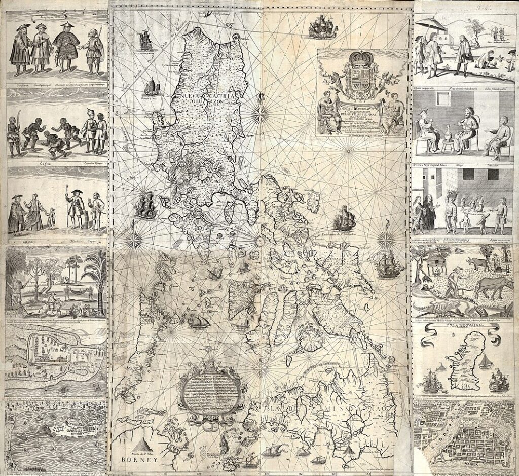
The Velarde Map, produced in 1734 by Spanish cartographer Pedro Murillo Velarde, is a comprehensive and detailed map of the Philippines. This map was commissioned by the Spanish crown to aid in the administration of its colonies in Asia. It is one of the earliest and most detailed maps of the Philippines, marking geographical locations and military posts crucial for the Spanish empire. The map includes annotations in Spanish, depicting various regions of the islands. It helped the Spanish establish better control over the archipelago’s resources and territories.
The Velarde Map is essential for understanding the colonial influence of Spain in the Philippines. It is considered a valuable historical artifact because of its precision and depiction of the islands during the 18th century. The map’s impact is seen in its role in guiding Spanish military and civil expeditions during the colonial period. Today, a surviving copy of the Velarde Map is held in the Philippine National Library and has been valued at around $170,500 in auctions. Its rarity and importance continue to make it a sought-after piece for collectors and historians alike.
Waldseemuller Map
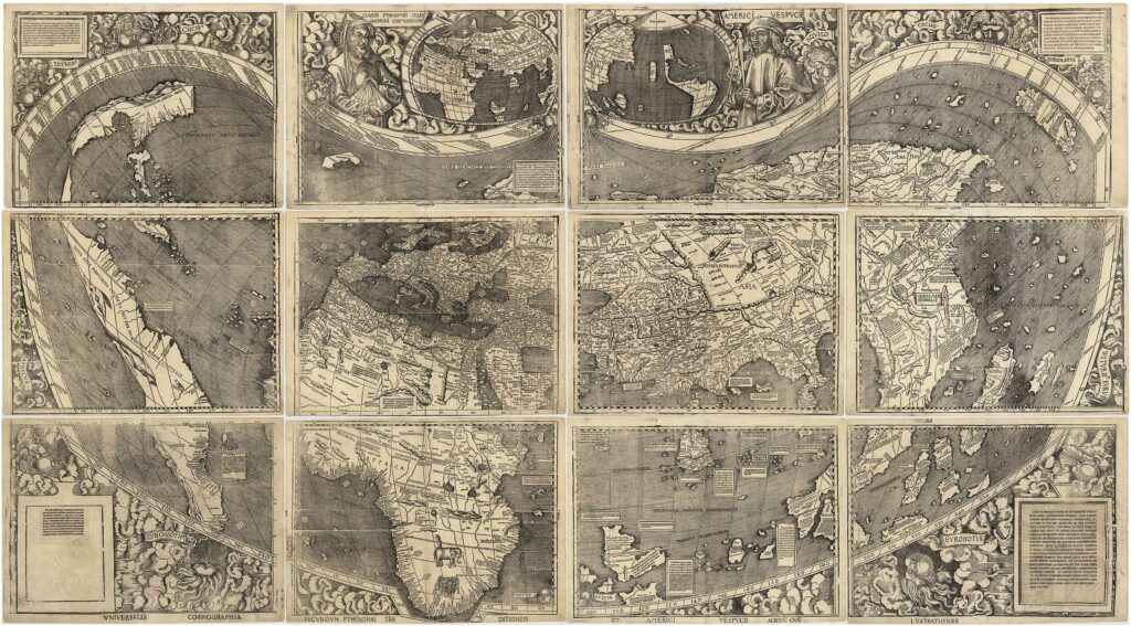
The Waldseemuller Map, created in 1507, is historically significant for being the first to name the New World America. This map was designed by German cartographer Martin Waldseemuller and included a detailed depiction of the Western Hemisphere. It is recognized as one of the first maps to show the Americas distinctly, with Europe, Africa, and Asia placed at the top of the map. The map was produced during the Age of Exploration, marking a turning point in geographical awareness. It is now preserved at the Library of Congress, and a single surviving copy was auctioned for millions of dollars.
This rare map is crucial for understanding the geographical and political views of the world in the early 16th century. It helped shape European exploration and understanding of the Americas. Waldseemuller’s map is also notable for its precise cartographic accuracy considering the time period. Its inclusion of America set a precedent for later maps and contributed to the naming of the continent. Due to its rarity and historical value, the map is estimated to be worth around $10 million, making it one of the most expensive historical maps in existence.
Dura-Europos Route Map
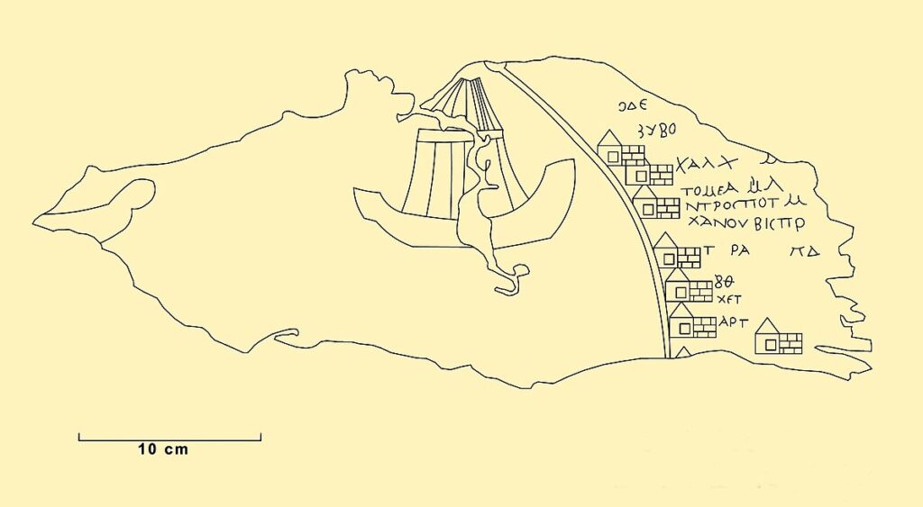
The Dura-Europos Route Map, discovered in Syria in 1923, is one of the oldest surviving military road maps. It was created during the Roman Empire, detailing the routes between Roman military forts and outposts along the Euphrates River. This leather map was part of a larger collection of military items and was likely used by Roman soldiers for strategic planning and logistics. It is incredibly valuable for understanding the Roman military’s operational organization during the 3rd century. The map is now housed in the Bibliothèque nationale de France.
This map is significant because it provides insight into Roman military communication and territory management. It helped soldiers and commanders plan their movements and responses to military threats in the region. The Dura-Europos Route Map also showcases the Romans’ advanced understanding of geography for military purposes. Its importance is seen in its preservation of tactical knowledge from nearly 2,000 years ago. While its market value is immeasurable due to its unique status as the oldest known military map, it is considered an invaluable piece of ancient military history.
Ferraris Map
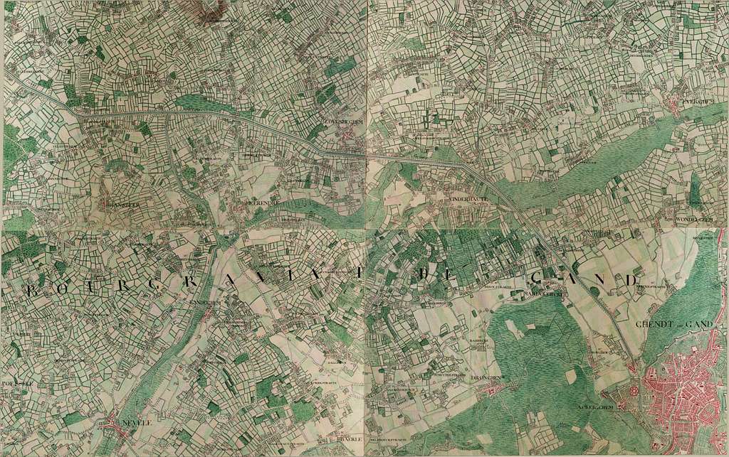
The Ferraris Map, created between 1770 and 1778, offers a comprehensive topographic survey of the Austrian Netherlands, which includes modern-day Belgium. Commissioned by the Austrian government, this map was designed to serve military and administrative needs. It is incredibly detailed, showing terrain, roads, and important locations. The map is often noted for its accuracy and the intricate details that were not available in other maps of the time. It was a vital tool for military planners and civil officials during the 18th century.
The Ferraris Map played an essential role in military operations, particularly during the period of the French Revolutionary Wars. It helped military leaders plan battles and maneuvers by providing a clear depiction of the terrain. Due to its detailed nature, it also became a reference for future mapmakers. The Ferraris Map remains highly prized by collectors and historians. With surviving copies held in the Royal Library of Belgium and the Austrian National Library, its market value can reach up to $200,000 depending on the condition of the map.
Great Polish Map of Scotland
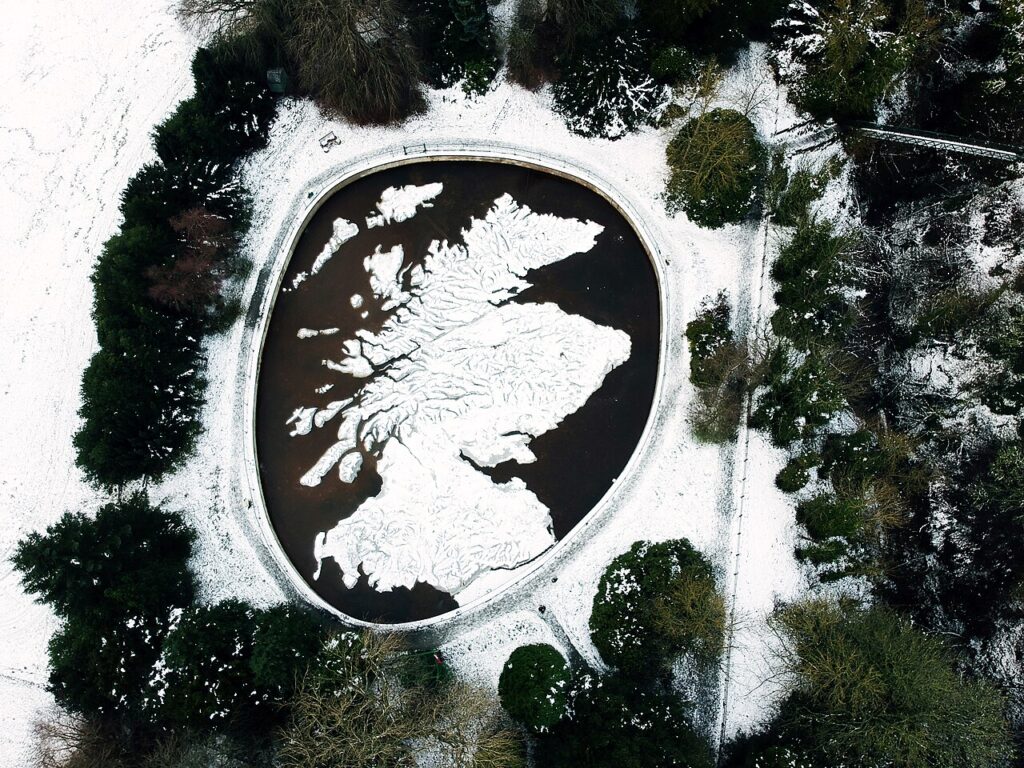
The Great Polish Map of Scotland, constructed between 1974 and 1979, is a remarkable three-dimensional map that covers 40 acres of land in Eddleston, Scotland. Designed by Polish war veteran Jan Tomasik, it was used as a military training tool for Polish soldiers during World War II. The map provides detailed topographic views of Scotland, focusing on its terrain, hills, and strategic routes. This massive relief map helped soldiers understand the geography of Scotland during the war, aiding in strategic planning. It is now a significant landmark and a tourist attraction in Scotland.
The Great Polish Map of Scotland remains a testament to the collaboration between Poland and the UK during World War II. Its creation was part of military training efforts to prepare soldiers for battlefield conditions. The map is an extraordinary example of how cartography was utilized for military purposes during wartime. Today, it is considered both a historical and cultural treasure, providing insights into military geography. While its exact market value is difficult to determine, its unique status makes it an invaluable piece of military history.
Tabula Rogeriana
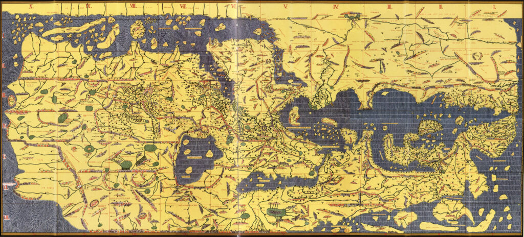
The Tabula Rogeriana, created by the Arab cartographer Al-Idrisi in 1154, is one of the most advanced and accurate world maps of the medieval period. Commissioned by King Roger II of Sicily, this map offered a unique view of the world, with the southern hemisphere placed at the top. Al-Idrisi’s map included detailed depictions of Europe, Asia, and Africa, incorporating the knowledge of both the ancient Greek world and the Islamic world. The map helped to challenge the Western European view of the world and provided crucial geographic knowledge during the Age of Exploration. The original is held at the Bibliothèque nationale de France.
The Tabula Rogeriana is notable for its role in bridging Eastern and Western geographical knowledge during the Middle Ages. It offered a more accurate portrayal of the continents compared to earlier maps, influencing future cartography and navigation. The map is revered as a monumental achievement in both historical geography and Islamic scholarship. As a result of its importance, the Tabula Rogeriana is considered one of the most valuable historical maps, with market values reaching into the millions depending on the copy and its condition. This map remains a vital reference in the study of medieval cartography.
Jean Baptiste Nolin’s Globe Terrestre
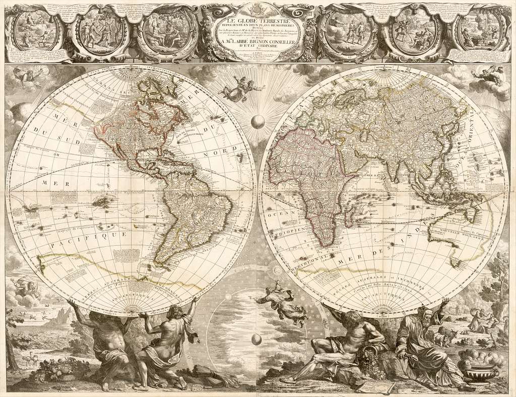
The Globe Terrestre, created by French cartographer Jean Baptiste Nolin in 1775, is a remarkable two-hemisphere world map. This large, finely engraved map featured sixteen illustrated vignettes that depicted contemporary historical events. The map is historically significant for its accuracy and artistic details, showcasing geographical knowledge and cultural views of the late 18th century. It was intended to provide a visual and informative representation of the world during the Enlightenment era. The Globe Terrestre is often seen as an artistic and cartographic masterpiece.
The map offers a fascinating insight into the global awareness of the time, with each of its vignettes providing a snapshot of major historical, cultural, and geographic milestones. Its detailed engravings not only served as an educational tool but also reflected the French Enlightenment’s intellectual and artistic endeavors. Today, surviving copies of this map are valued at $18,000 to $20,000 at auction, making it a highly sought-after collector’s item. The map is treasured for its rare combination of historical and artistic value, which has helped it stand the test of time. It remains a prized artifact for collectors of historical maps and 18th-century French artifacts.
Qianren Huang’s Complete Map of Qing Empire
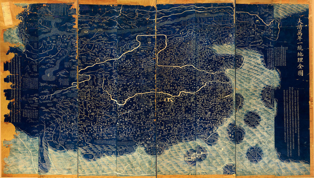
Created by Qianren Huang in 1814, this map offers a comprehensive depiction of the Qing Empire at its territorial zenith. The map was based on research conducted for the Qianlong emperor in 1767, and it highlights the empire’s vast territory, stretching from the Eastern Sea to Central Asia. It was designed to help the Qing dynasty maintain control over its extensive land and peoples, serving both a political and military purpose. The map is notable for its precise detailing of the empire’s borders and its representation of China’s influence in the region. It provides valuable insights into the geopolitical concerns of the Qing Dynasty in the early 19th century.
The map is considered one of the most important cartographic works from the Qing period, as it demonstrates the dynasty’s territorial control and strategic importance. Its impact on both military and administrative affairs is significant, as it aided in the empire’s defense and expansion strategies. Today, the Qianren Huang map is a rare artifact, with estimated market values ranging from $100,000 to $120,000 depending on the condition of surviving copies. As one of the few remaining examples of its kind, it holds immense historical and cultural value. The map offers a crucial window into the territorial ambitions and organizational strategies of the Qing Empire.
Giacomo Gastaldi’s Totius Orbis Descriptio
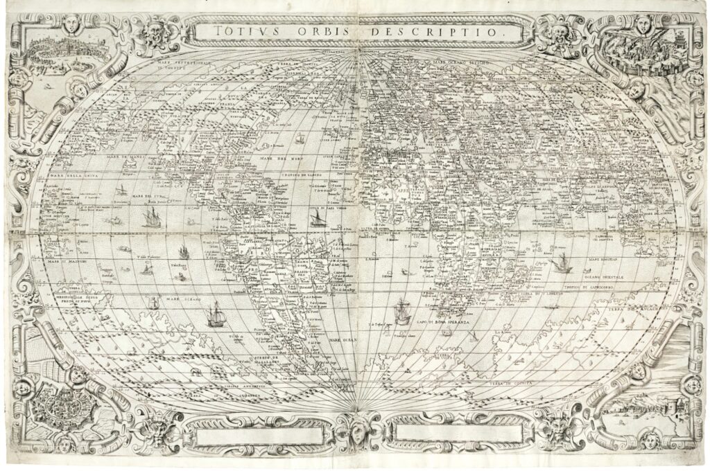
Giacomo Gastaldi’s Totius Orbis Descriptio, produced around 1570, is one of the most important world maps of the 16th century. The map represents a significant step in the development of cartography during the Renaissance period. Gastaldi’s map was one of the first to depict the Americas with a more accurate portrayal, incorporating new knowledge from explorers of the time. It offers a global view with Europe, Africa, and the Americas clearly outlined, reflecting the growing European awareness of the New World. The map’s influence extended to both geographical studies and the practical aspects of navigation during the Age of Exploration.
The Totius Orbis Descriptio is known for its precision and its representation of the Western Hemisphere, which was still largely unknown to most Europeans. It marks an important point in the development of maps as tools for both exploration and trade. Original copies of this map are highly valuable, with some examples estimated to be worth around $100,000 to $150,000 at auction. This map continues to be a key object for studying the advancement of geographical knowledge and the global perceptions during the Renaissance. Its rarity and historical significance make it a sought-after piece for collectors and historians alike.
Piri Reis Map
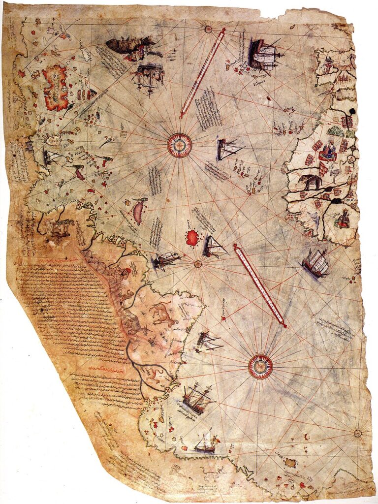
The Piri Reis Map, created by the Ottoman admiral and cartographer Piri Reis in 1513, is one of the most famous historical maps. It is known for its depiction of parts of Europe, Africa, and the Americas, including the coastlines of South America. The map is particularly intriguing because it includes an incredibly accurate representation of the South American coastline, far surpassing the European navigational knowledge of the time. Piri Reis compiled the map using earlier sources, some of which are believed to have been lost. The map is now preserved in the Topkapi Palace Museum in Istanbul, and it continues to be a source of fascination for historians and cartographers.
The Piri Reis Map is notable for its accurate portrayal of the South American continent, with details that would have been impossible for a mapmaker to know in 1513. It also includes portions of the Antarctic coastline, which has raised theories about ancient maritime exploration. The map is of immense historical and cultural value, with a market value that could range between $2 million and $3 million for the original. Its impact on both the study of cartography and the history of exploration is substantial. The map continues to spark debates about lost knowledge and ancient navigation techniques.
This article originally appeared on Avocadu.