12 Rare and Historical Antique Maps You Should Know About
Antique maps offer a fascinating glimpse into the past and reveal how people once viewed the world. Some of these maps are not only works of art but also critical documents of historical exploration and discovery. Over the centuries, these rare maps have become valuable treasures, sought after by collectors and historians alike. The stories behind these maps are just as intriguing as the artwork itself. By exploring their histories, we can better understand the progression of human knowledge and how cartography has shaped our understanding of the world.
This post may contain affiliate links, which helps keep this content free. Please read our disclosure for more info.
The Tabula Rogeriana
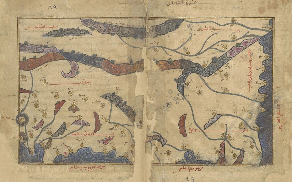
The Tabula Rogeriana, created by the Arab cartographer Al-Idrisi in 1154, is a highly accurate map for its time. It was produced for the Norman King Roger II of Sicily and is considered one of the most important medieval maps. The map portrays Europe, Asia, and parts of Africa with incredible detail, based on knowledge from Arabic, Persian, and Byzantine sources. Its estimated market value is around $1 million, reflecting its significance in the history of mapping.
This map stands out because of its accuracy and the breadth of the geographical knowledge it presents. Al-Idrisi’s work was more advanced compared to European maps at the time, providing a clearer depiction of the world. The map was used for navigation and scholarly purposes, making it an essential piece in understanding the medieval world. Its rarity and historical importance increase its value significantly in the map-collecting world.
The Ptolemaic Map of the World
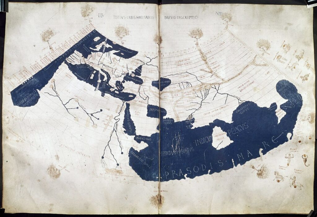
Created in 1482 by the famous cartographer Claudius Ptolemy, this map reflects the ancient understanding of the world. It includes a projection of Europe, Asia, and Africa, with a limited understanding of the Americas. The map is renowned for its accuracy at the time and is one of the earliest printed world maps. Its current market value is estimated at around $100,000 due to its historical significance and rarity.
The map is based on Ptolemy’s Geographia, which was a key influence on later cartography. It is a fascinating glimpse into how ancient civilizations viewed the world. Its value is driven by its age and the fact that only a few copies of the original prints still exist. The map is highly sought after by collectors of antique maps and historical artifacts.
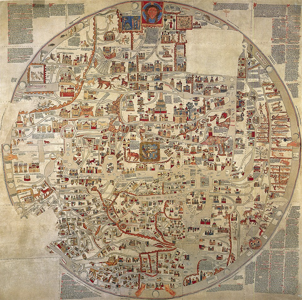
The Mappa Mundi of Hereford
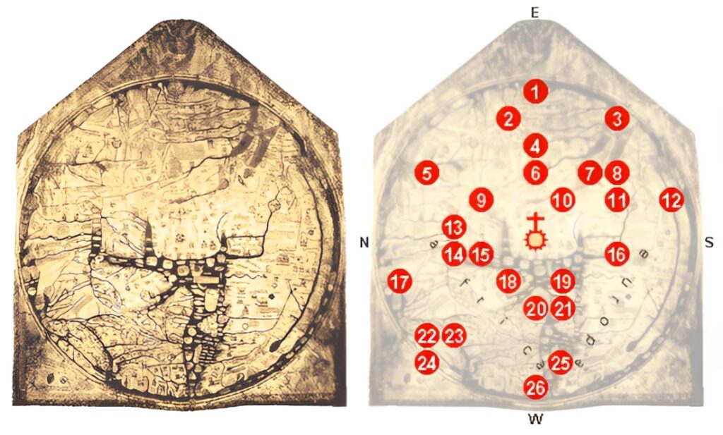
The Hereford Mappa Mundi, created around 1300, is the largest medieval map known to exist. This map represents both the physical and spiritual world as understood in medieval times, with Jerusalem at the center. Its detailed drawings show places of historical, mythological, and religious significance, making it an essential artifact of medieval cartography. The map’s current market value is difficult to estimate precisely but can range up to several million dollars due to its historical value.
This map is unique because it merges geography with religious and cultural beliefs, showcasing the medieval worldview. The amount of detail and craftsmanship involved in creating this massive map makes it highly valuable. It is displayed in the Hereford Cathedral in England, where it remains a key historical object. Its age, craftsmanship, and significance contribute to its rare status in the map-collecting community.
The Waldseemuller Map
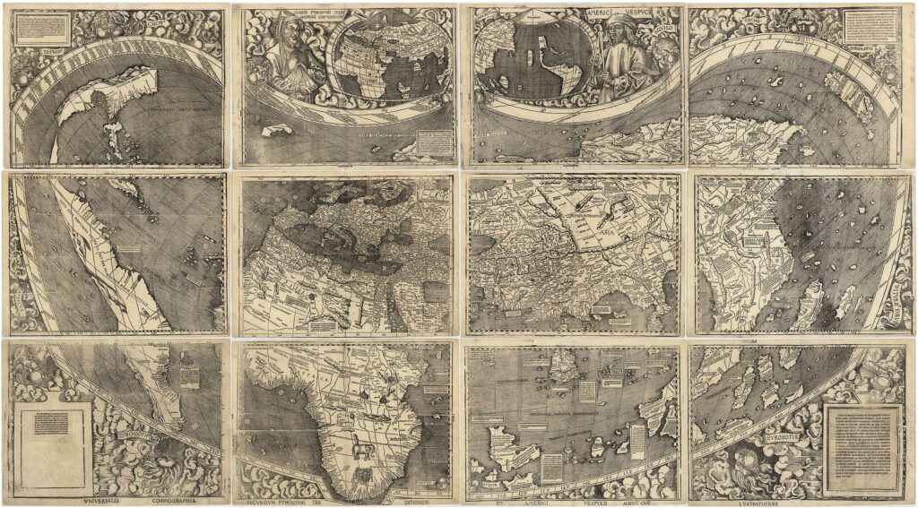
Created by Martin Waldseemuller in 1507, this map is famous for being one of the first to use the name America in reference to the New World. It was an early projection of the Western Hemisphere, including the Americas, based on new discoveries. The map was produced in a limited run, and surviving copies are highly prized today. Its market value is estimated at $10 million, making it one of the most expensive antique maps.
Waldseemuller’s map is significant because it marks a pivotal moment in the history of cartography, incorporating Columbus’ discoveries and naming the Americas. The map helped shape the understanding of geography during the Age of Discovery. Its rarity and historical importance make it a major piece for collectors of early maps and explorers’ history. Few copies remain, with most housed in museums or private collections.
The T and O Map
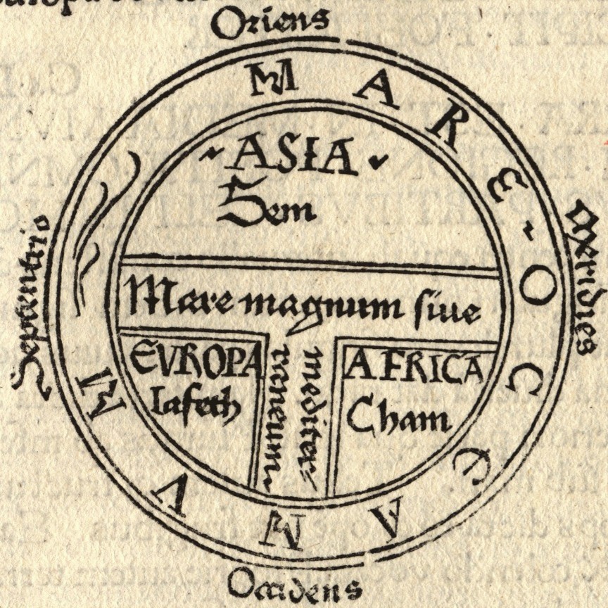
The T and O map, a popular form of medieval map, was created in the 1300s. This map style divides the world into three continents-Asia, Europe, and Africa-with the Mediterranean Sea forming the T shape. It was used to reflect the Christian worldview, with Jerusalem at the center. Its value is difficult to pin down but can range from $50,000 to $250,000 depending on the quality and condition.
This type of map was widely used during the Middle Ages to help illustrate the known world according to medieval thinkers. The T and O map represents a simplistic, symbolic view rather than an accurate geographical one. Although not highly detailed, it holds immense historical value for those studying medieval beliefs and geography. As an early form of world map, it remains a coveted item among map collectors.
The Piri Reis Map
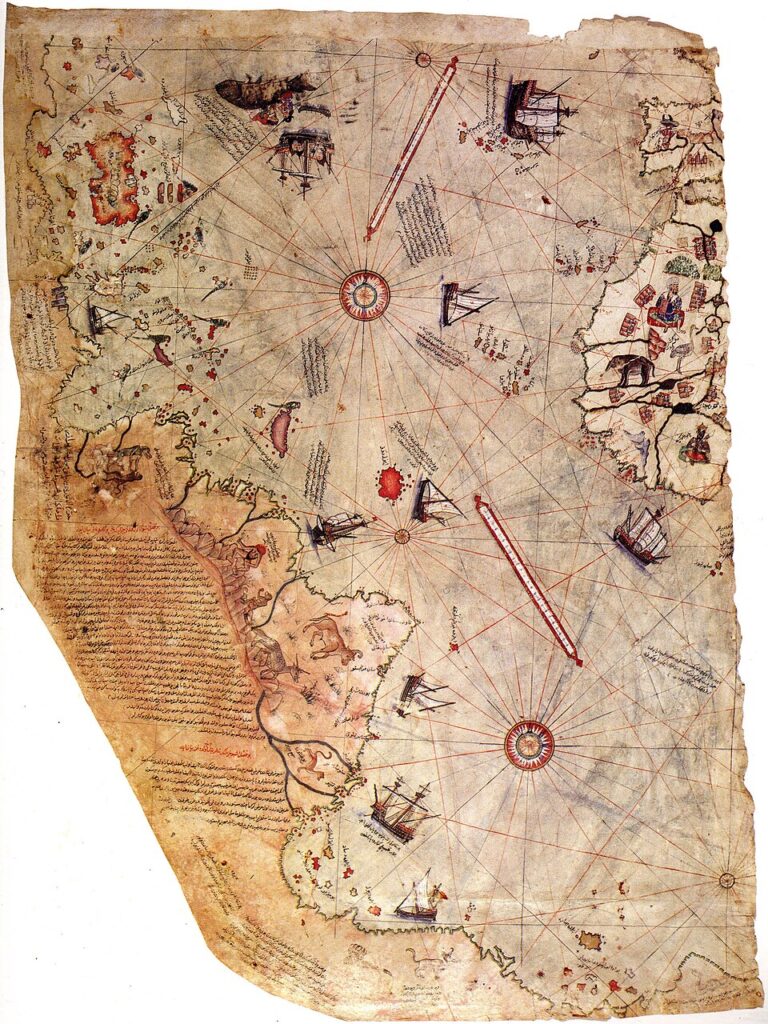
The Piri Reis map, created by the Ottoman admiral and cartographer Piri Reis in 1513, is famous for its depiction of the Americas and parts of the South Atlantic. This map is notable for its accuracy in showing the South American coastline and other regions, even though it was drawn before widespread exploration of the Americas. It is estimated to be worth around $2 million, with its rarity and historical importance being the key contributors to its value.
The map is unique because it was created using various older maps and documents, some of which were lost or unknown. It contains detailed and advanced depictions of areas that were unknown to Europeans at the time, leading to theories about ancient cartographic knowledge. The Piri Reis map remains a valuable artifact, both for its craftsmanship and its mystery surrounding the source of its information. It is an iconic piece for collectors of maps and historical curiosities.
The Cantino Planisphere
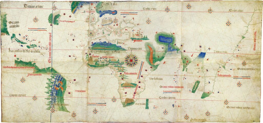
The Cantino Planisphere, created in 1502 by an unknown Portuguese cartographer, is one of the oldest surviving maps showing the New World. It was commissioned by the Portuguese government to reflect new discoveries in the Americas and Africa. The map is valued at $2 million due to its historical significance and the rare glimpse it provides into early 16th-century exploration. The Cantino Planisphere offers a look into how the world was viewed by Europeans during the Age of Exploration.
The map is considered an important document in the history of cartography, as it was one of the first to incorporate new geographical discoveries from Portuguese explorers. It shows the coastlines of Africa, the Americas, and parts of Asia. The Cantino Planisphere is not only a map but also a historical artifact that helped shape European navigation and exploration. Its age and rarity contribute to its substantial market value.
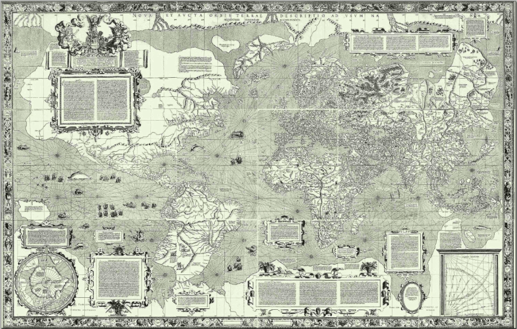
The Blaeu Atlas Maior
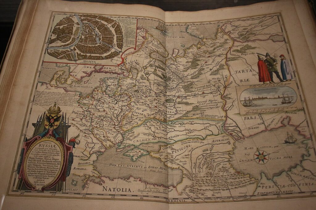
The Blaeu Atlas Maior, created in 1662 by the Dutch cartographer Joan Blaeu, is considered one of the finest atlases ever published. It contains over 600 maps, covering continents, countries, and regions with incredible detail and accuracy. The value of this atlas can reach up to $1.5 million, depending on its condition and completeness. Its historical importance and the skill in producing such detailed works contribute to its high value.
This atlas represents the peak of 17th-century cartography, with finely engraved maps that showcase the political and geographical knowledge of the time. Blaeu’s work includes detailed depictions of European, Asian, and African countries, making it invaluable for historians and collectors. The Atlas Maior was commissioned by the Dutch East India Company and used for navigational purposes. Its stunning craftsmanship and historical significance make it a top choice for collectors of antique maps.
The Hunt-Lenox Globe
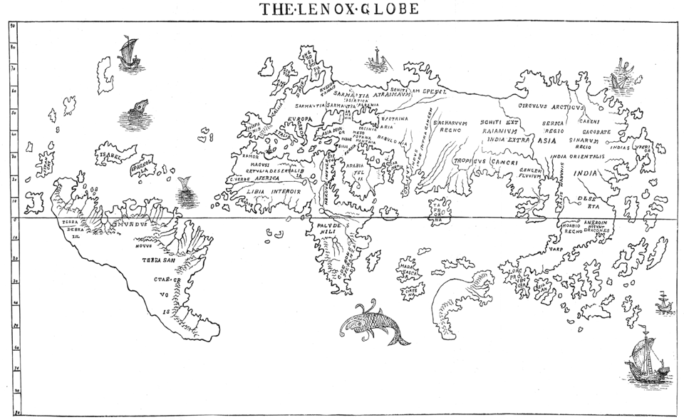
The Hunt-Lenox Globe, created around 1510, is one of the oldest surviving terrestrial globes. It is believed to be one of the first globes to depict the Americas, showing them as separate landmasses. Its current market value is estimated at $10 million due to its rarity and the historical importance of its content. The globe is unique for being one of the few surviving artifacts from the early 16th century.
This globe offers an insight into early European exploration, and it is considered a key object in the history of cartography. It shows the world as it was understood at the time, with places like Africa and Asia depicted based on recent discoveries. The globe has been carefully preserved, and its historical context only increases its desirability among collectors. The Hunt-Lenox Globe is a rare and priceless artifact, representing a significant moment in world history.
The Ebstorf Map
The Ebstorf Map, created in the 14th century, is one of the largest medieval world maps ever produced. It measured about 3.5 meters in diameter and depicted the world in a circular format with Jerusalem at the center. The map was destroyed during World War II, but replicas and descriptions of it still exist, making it a highly sought-after piece for collectors. Its historical value is immeasurable, as it provided a unique view of the medieval worldview.
The Ebstorf Map was created by an unknown artist in Germany and was used for educational and religious purposes. It is famous for its rich symbolism, combining geographic, historical, and biblical elements. Although the original is lost, its replicas and descriptions continue to fascinate historians and map collectors. The value of any remaining pieces or replicas of the map is substantial due to the rarity and importance of the original.
The Mercator Map
The Mercator Map, created by Gerardus Mercator in 1569, was one of the first maps to use a cylindrical projection. This map revolutionized navigation by providing straight lines for sailors to follow, making it highly valuable for maritime exploration. Its estimated market value is around $500,000 due to its historical importance in cartography and its rarity. The map is still widely used in modern navigation and remains a major work in the history of mapmaking.
Mercator’s innovation in creating a map that allowed for more accurate sea travel had a significant impact on exploration. The map depicts the world as it was understood in the late 16th century, with Europe at the center. Mercator’s projection was a major breakthrough in the field of cartography, and this map marked a turning point in how the world was visualized. Its continued influence and historical importance contribute to its high market value.
The Behaim Globe
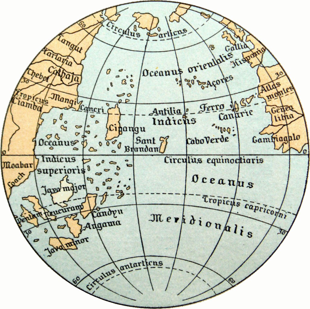
The Behaim Globe, created in 1492 by German cartographer Martin Behaim, is the oldest surviving terrestrial globe. It features an early depiction of the world, including parts of the Americas, which had not yet been fully explored by Europeans. The globe is valued at around $10 million due to its rarity and its significant role in the history of exploration. It is a symbol of the early age of global navigation and exploration.
The Behaim Globe is notable for its historical context, as it was created just before Columbus’ voyage to the New World. It shows Europe, Africa, and Asia in great detail but lacks accurate representations of the Americas. This globe provides a unique perspective on how Europeans viewed the world before widespread exploration. Its rarity and historical significance make it one of the most valuable and sought-after items in cartography.
Rare antique maps are not just valuable collectibles; they are windows into the past, offering unique insights into historical exploration and discovery. For collectors and history enthusiasts, owning or studying these maps provides a tangible connection to the world’s past. With their rich histories and artistic beauty, these rare maps continue to captivate and inspire, making them highly sought-after treasures in the world of antiques.
This article originally appeared on Avocadu.