10 Collectible Maps and Charts Used by Armed Forces
Throughout history, armed forces have relied on maps and charts to guide their movements and operations. These documents were crucial for soldiers and strategists in determining routes, targets, and enemy positions. Today, many of these maps have become rare and collectible items for military enthusiasts. Their detailed designs and historical context make them valuable artifacts.
This post may contain affiliate links, which helps keep this content free. Please read our disclosure for more info.
WWII U.S. Army Topographic Maps
World War II U.S. Army topographic maps were used extensively for navigation and strategic planning during the war. These maps depicted detailed terrain features such as roads, rivers, and elevation changes, crucial for soldiers in unfamiliar areas. They helped military leaders make informed decisions about troop movements and supply routes. Many of these maps are highly sought after by collectors today due to their historical significance. The current value of these maps ranges from $50 to $200, depending on condition and rarity.
Topographic maps were critical in both tactical and operational planning. They were produced in large quantities during the war but were often discarded after use, making well-preserved examples rare. Many collectors focus on maps from key battles or campaigns such as Normandy or the Pacific Theater. The fine details and markings on these maps add to their appeal. With their strong ties to military history, these maps continue to be valuable collectibles.
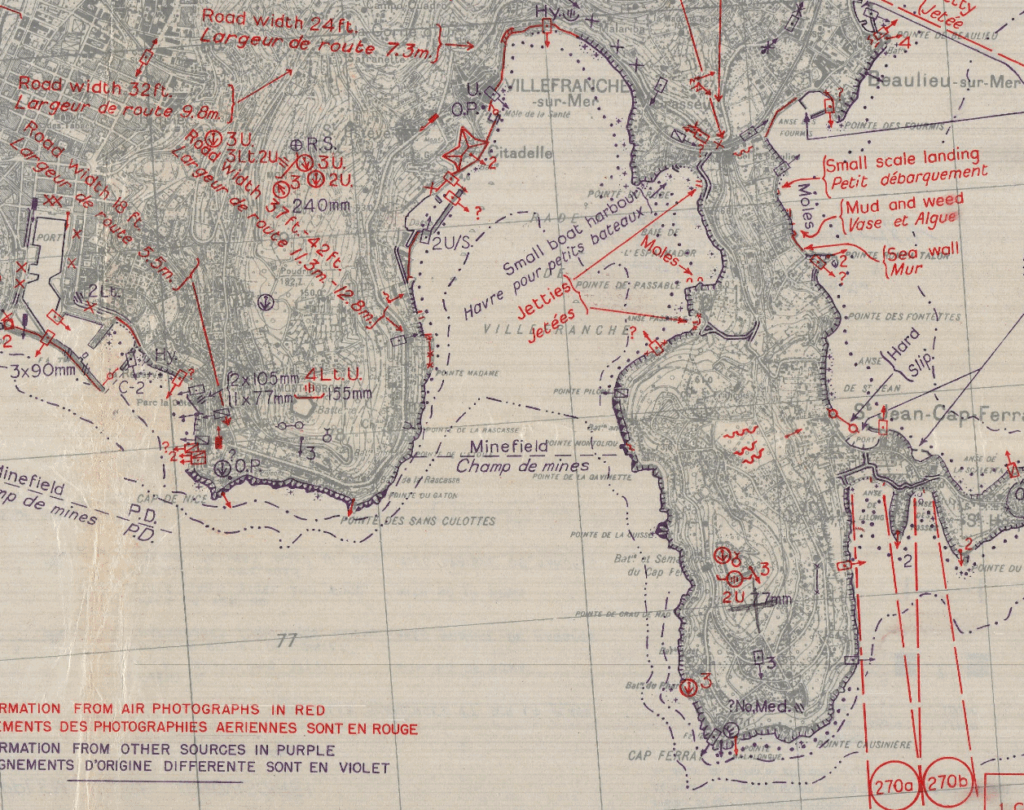
U.S. Navy World War II Hydrographic Charts
The U.S. Navy used hydrographic charts during WWII to navigate and plan maritime operations. These charts displayed critical information about coastal waters, including water depths, hazards, and navigation routes. Hydrographic charts were essential for naval battles, amphibious landings, and securing shipping lanes. Many of these charts, particularly those covering the Pacific Ocean and Mediterranean Sea, have become valuable collector’s items. These charts typically range in value from $100 to $500, depending on their condition and specific area covered.
Hydrographic charts were updated regularly based on new data from naval vessels and reconnaissance. They were used to guide U.S. Navy ships through contested waters and help prevent navigational errors during wartime. Today, these charts serve as a unique glimpse into military naval operations during WWII. The precision and detail they offer continue to captivate collectors and historians. Collectors often seek charts from pivotal locations such as Pearl Harbor or the D-Day landings.
U.S. Army World War I Trench Maps
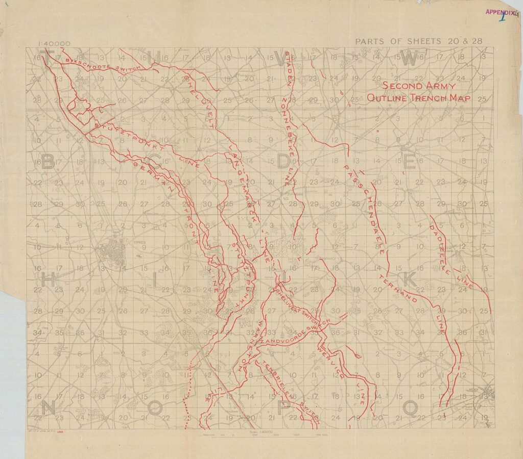
Trench maps were created by the U.S. Army during World War I to guide soldiers through the complex network of trenches and battlefields. These maps depicted the locations of trenches, barbed wire, artillery positions, and enemy lines. Trench warfare was a key feature of WWI, and these maps were crucial for commanders and troops to understand the battlefield. Trench maps are rare today and highly collectible, with values ranging from $100 to $500, depending on their condition and historical importance.
These maps were hand-drawn and often updated during the war to reflect changes in the front lines. They were used in conjunction with other intelligence to plan offensives and defensive strategies. The detailed markings on the maps allowed soldiers to navigate the dangerous and often disorienting conditions of trench warfare. Due to the physical nature of trench warfare and the intense combat, these maps are a rare and precious piece of history. Collectors often seek trench maps from key battles like the Battle of the Somme or Verdun.
U.S. Military Map of the Korean War
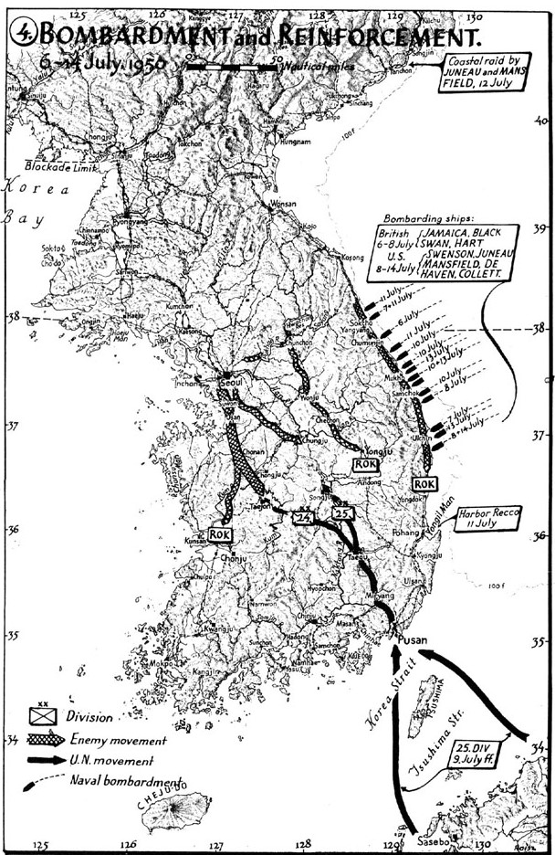
Maps of the Korean War were essential for military strategy and operational planning during the conflict. These maps provided detailed information on troop positions, key cities, and terrain features, which were crucial for military leaders to make tactical decisions. The maps produced during the Korean War are highly sought after for their historical value and the dramatic events that took place during the conflict. Collectors can expect to pay between $75 and $350 for a well-preserved map, depending on its significance.
The Korean War maps were meticulously designed and updated during the conflict to keep track of rapidly changing front lines. Some maps even included detailed depictions of enemy positions, which were vital for U.S. and allied forces during critical moments of the war. As many maps were produced for specific operational purposes, they often carry unique markings or annotations, making them highly collectible. These maps are a tangible link to a war that shaped U.S. foreign policy during the Cold War era.
German WWII Military Maps
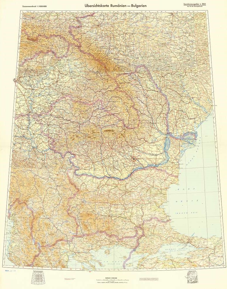
German military maps from World War II are highly collectible due to their detailed design and historical significance. These maps were used by the Wehrmacht and provided strategic insights into the Eastern and Western Fronts. German maps were known for their precision, often detailing everything from enemy positions to supply routes and terrain features. Depending on rarity and condition, these maps can range from $100 to $600 in value.
German military maps were often marked with secret codes and symbols for operational use, making them valuable historical documents. The maps provided crucial information for the planning of military campaigns, including Operation Barbarossa and the defense of Berlin. Today, these maps offer a unique glimpse into the military strategy of one of history’s most infamous armies. Collectors seek maps from significant campaigns and battles, such as Stalingrad and Normandy.
U.S. Army Vietnam War Tactical Maps
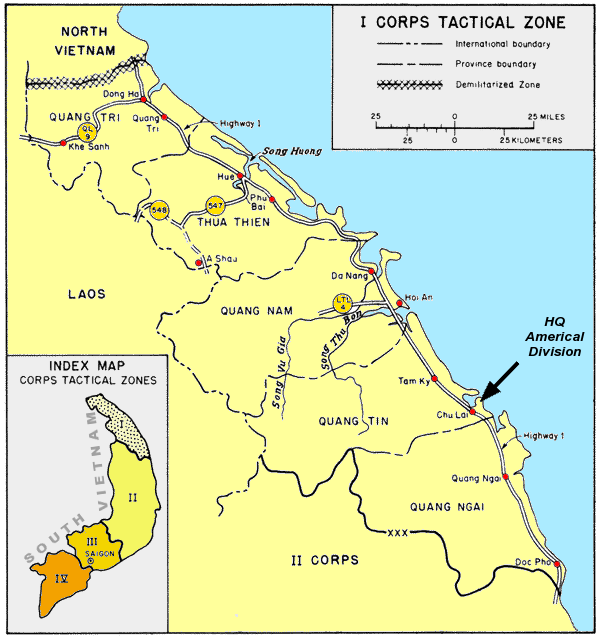
U.S. Army tactical maps from the Vietnam War were essential for military planning and execution during the conflict. These maps were used to understand the complex terrain of Vietnam, which posed unique challenges for military operations. The maps often depicted key areas such as supply routes, enemy troop positions, and fortified locations. Due to their historical significance, these maps can be worth between $100 and $500, depending on their rarity and specific use.
The maps were used to plan both large-scale military offensives and smaller, tactical operations. Some maps were created to assist in counterinsurgency efforts and to locate hidden enemy camps. Many of these maps were marked with specific intelligence gathered from reconnaissance and field reports, making them valuable sources of information. Collectors of Vietnam War artifacts highly prize these maps for their direct connection to the conflict.
U.S. Civil War Battlefield Maps
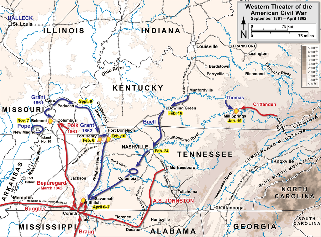
During the U.S. Civil War, battlefield maps were crucial for both Union and Confederate forces to plan military operations. These maps depicted the locations of key features such as rivers, roads, and fortifications, and were used to chart troop movements. Civil War battlefield maps provide valuable insight into some of the most significant battles in American history. Prices for these maps range from $100 to $400, depending on the battle or location depicted.
The maps were used by generals and commanders to guide their troops and make critical decisions during battle. Many of these maps were hand-drawn and updated as the situation on the ground evolved. Today, Civil War battlefield maps are prized by collectors for their historical importance and rare nature. Collectors often seek maps of famous battles such as Gettysburg, Antietam, and Chickamauga.
U.S. Army Desert Storm Maps
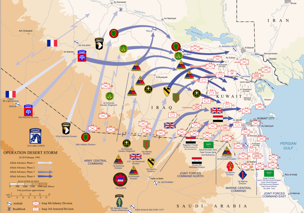
Maps used during Operation Desert Storm provided critical information about the terrain and enemy positions in the Middle East. These maps were crucial for U.S. military forces during their ground operations in Iraq and Kuwait. The maps offered detailed depictions of urban areas, roads, and natural features, making them essential for successful military campaigns. Collectible Desert Storm maps can range in value from $50 to $200, depending on their rarity and condition.
These maps were created to support both ground troops and air operations during the 1991 Gulf War. They were updated frequently to reflect changes in the battlefield, and many were marked with special notations for operational use. Today, Desert Storm maps are a unique part of modern military history and are valued by collectors for their connection to a pivotal conflict. They provide insight into the tactical challenges faced by U.S. forces in a desert environment.
U.S. Army WWII Air Force Navigation Charts
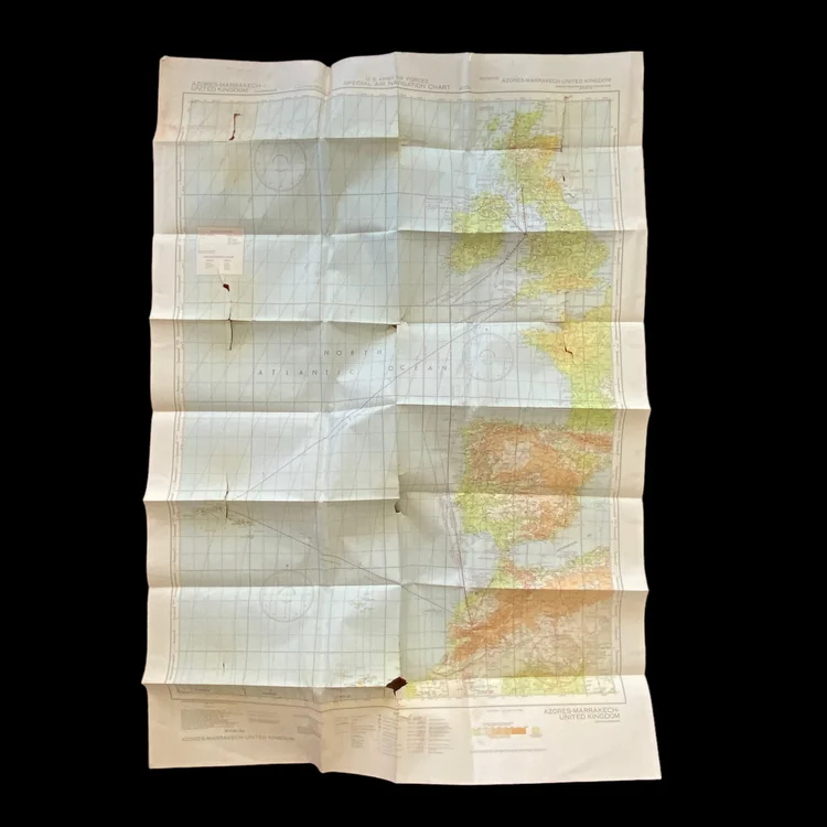
Air Force navigation charts from WWII were critical for pilots navigating the skies during military operations. These charts provided detailed routes, airfields, and danger zones, allowing pilots to safely navigate through enemy territory. They were especially valuable during long-range bombings and reconnaissance missions. Collectible navigation charts can range in price from $100 to $400, depending on rarity and condition.
These charts were produced by the U.S. Army Air Force and were updated regularly based on intelligence reports. They were used to guide pilots over long distances, often under challenging and hostile conditions. The charts played a key role in the success of bombing raids and air campaigns. Today, these charts are valuable historical documents for collectors of military aviation artifacts.
U.S. Army D-Day Landing Maps
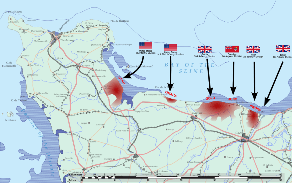
The D-Day landing maps used during the Normandy invasion were essential for the planning and execution of Operation Overlord. These maps depicted landing zones, beachheads, and the locations of enemy fortifications. They were used by military leaders to guide the landing forces and ensure a successful invasion. D-Day landing maps are highly collectible, with prices ranging from $150 to $600, depending on their condition and historical significance.
These maps were key for the success of the largest amphibious assault in history. They provided detailed information about the coastline, enemy positions, and logistical needs for the landing forces. Today, D-Day landing maps are prized by collectors and historians for their connection to one of the most pivotal events of World War II. They are a valuable resource for understanding the scale and complexity of the invasion.
Military maps and charts continue to be sought after for their historical significance and detailed accuracy. They offer a unique look into the strategies and movements that shaped major conflicts. The value of these maps goes beyond their practical use, offering a glimpse into the world of armed forces through time.
This article originally appeared on Avocadu.