11 Antique Maps and Globes That Tell the Story of History
Maps and globes from centuries past are not just tools for navigation. They are valuable pieces of history that offer insights into the ways people viewed the world long ago. The artistry and craftsmanship behind these maps reflect the cultures and technologies of their time. Whether you are a collector or simply curious about history, these maps and globes provide a fascinating glimpse into our collective past. Let us explore some of these remarkable treasures that have stood the test of time.
This post may contain affiliate links, which helps keep this content free. Please read our disclosure for more info.
16th Century World Map by Gerardus Mercator (1569)
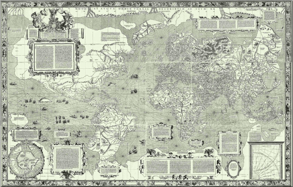
Gerardus Mercator’s 1569 world map is one of the most significant cartographic works of its time. It introduced the Mercator projection, revolutionizing navigation and cartography. This map was vital for navigators and explorers, offering a more accurate depiction of the world’s geography during the Age of Exploration. The current market value for an original map can range from $3 million to $10 million, depending on its condition and rarity.
Although original copies are rare and typically housed in major libraries and institutions, high-quality reproductions are available for those interested in owning a piece of history. These reproductions generally range from $30 to $100, making them more accessible for collectors. The map’s enduring legacy in modern navigation adds to its high value in the antique market. It remains a vital artifact of the Renaissance period and the growth of global exploration.
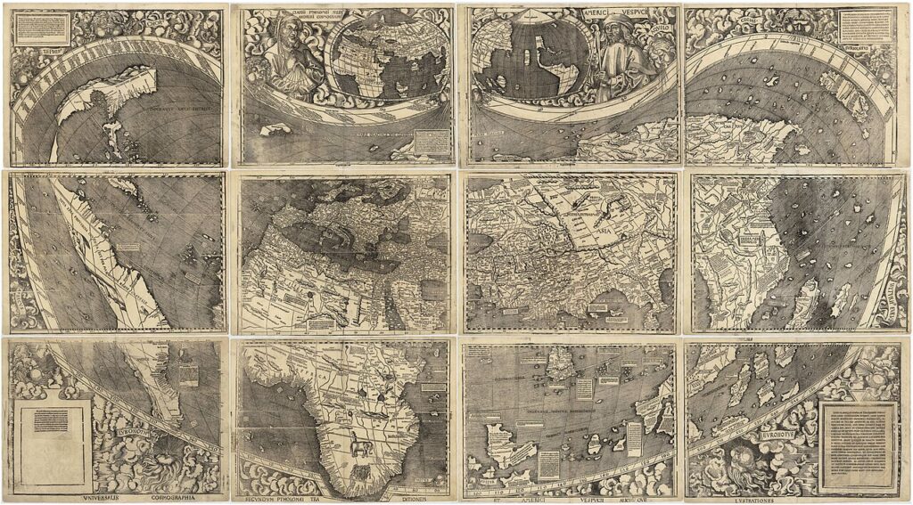
The Ptolemaic World Map (2nd Century AD)
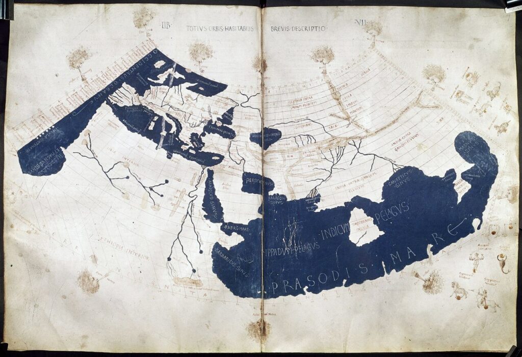
The Ptolemaic world map, created by the Greek scholar Claudius Ptolemy in the 2nd century AD, is one of the earliest known maps to use a coordinate system. It depicted the world as understood during ancient times, with a focus on the Mediterranean and surrounding regions. The map’s influence on later cartography is immense, providing the framework for many subsequent maps throughout history. Original manuscripts of the Ptolemaic map are considered priceless and are rarely available for purchase.
Modern reproductions of this ancient map can range in price from $50 to $200, depending on quality and size. These reproductions allow history enthusiasts and collectors to explore the ancient world’s understanding of geography. The Ptolemaic map tells the story of early scientific thought and the evolution of cartographic practices. It is an essential piece for those interested in the development of mapmaking and ancient civilizations.
The Tabula Rogeriana (1154)
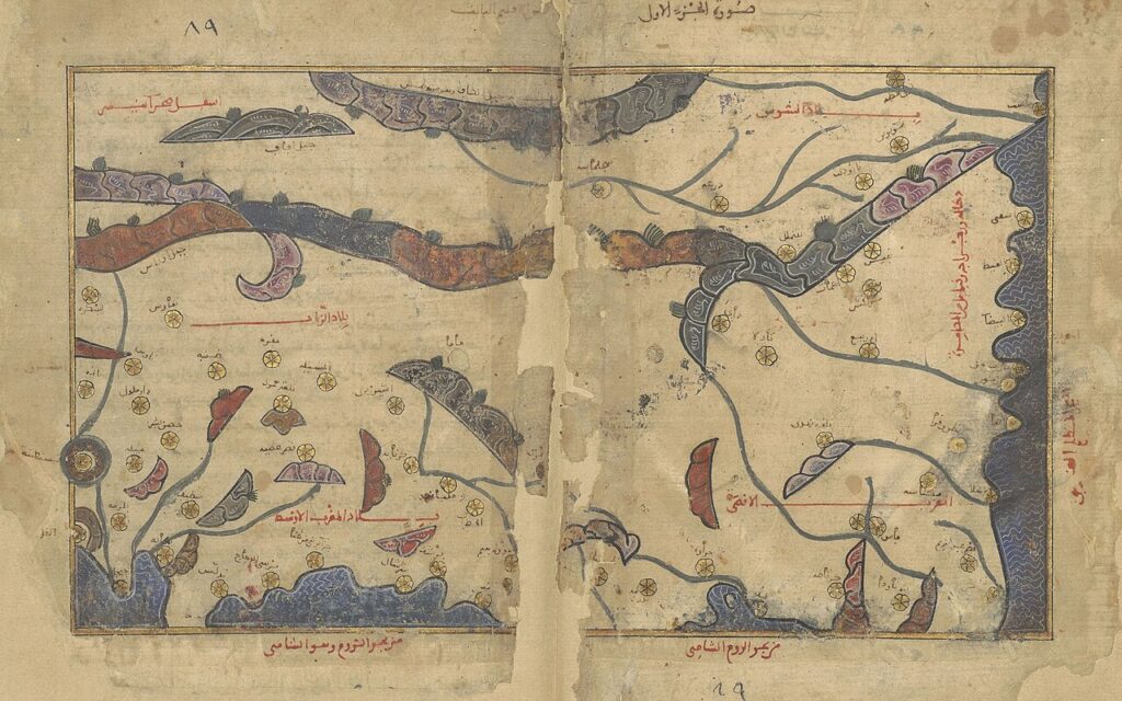
The Tabula Rogeriana, created by the Arab geographer al-Idrisi in 1154, is a world map that offers a highly advanced view of the known world during the medieval Islamic period. It was commissioned by the Norman king Roger II of Sicily and includes details of Europe, Africa, and Asia. The map is an example of how the Islamic world preserved and expanded upon ancient Greek and Roman geographic knowledge. Original copies of the map are extremely rare, with significant historical value and no fixed market price due to their scarcity.
Reproductions of the Tabula Rogeriana are more commonly available and can be found for around $100 to $300, depending on the quality. These reproductions provide insight into medieval geography and the fusion of knowledge from different cultures. The map’s advanced depiction of the world reflects the intellectual achievements of the Islamic Golden Age. Its significance lies in how it influenced future cartographic efforts in both the East and West.
The Cantino Planisphere (1502)
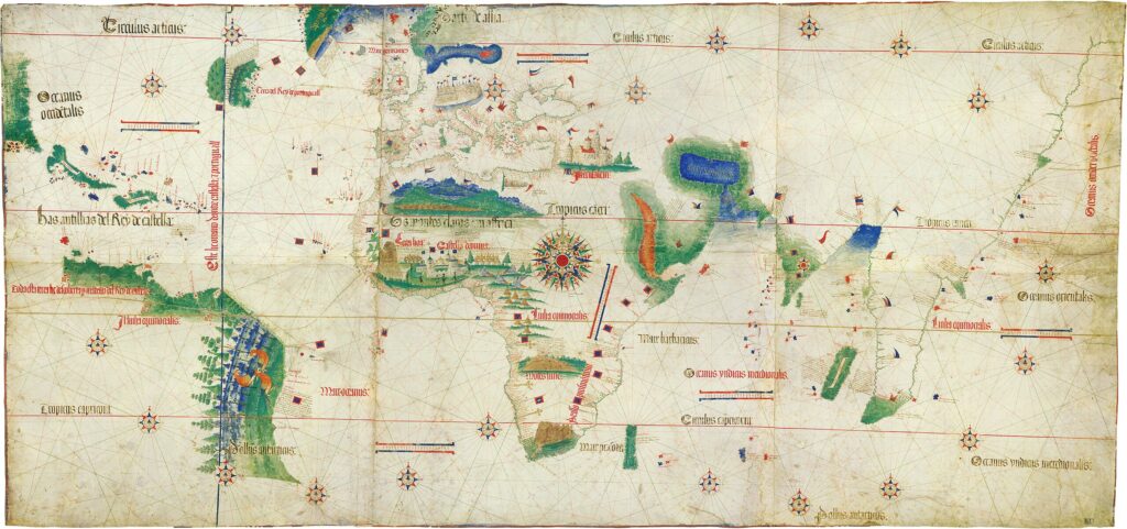
The Cantino Planisphere, created in 1502, is a Portuguese world map that provides one of the earliest accurate depictions of the Americas. It was used to showcase newly discovered lands along the African coast and the Americas, reflecting the growing Portuguese empire. The map is a significant historical artifact, illustrating the beginning of European expansion and exploration. Original maps are rare and are typically held in major museums, with no standard market value due to their rarity.
High-quality reproductions of the Cantino Planisphere are available for collectors, with prices typically ranging from $50 to $200 depending on quality and size. The map remains a valuable historical document that illustrates the early stages of European exploration and trade. Its artistic design and historical significance make it a sought-after piece among cartography enthusiasts. Owning a reproduction allows collectors to appreciate the early mapping of the New World and its role in shaping global exploration.
Martin Waldseemuller World Map (1507)
Martin Waldseemuller’s 1507 world map is historically significant for being one of the first to use the name America” in reference to the newly discovered continent. This map represents the early European understanding of the New World and shows South America as a distinct landmass. The map is a key document in the history of cartography and the Age of Discovery. Original versions of the map are incredibly rare, with some having sold at auction for upwards of $10 million, depending on condition and provenance.
Reproductions of Waldseemuller’s 1507 map are available, typically ranging from $30 to $100. These reproductions allow collectors to explore the map’s early depiction of the Americas and Europe. The map’s inclusion of the name “America” marked a shift in European thought and helped solidify the New World in global consciousness. Its significance in the history of cartography continues to attract interest from historians and collectors alike.
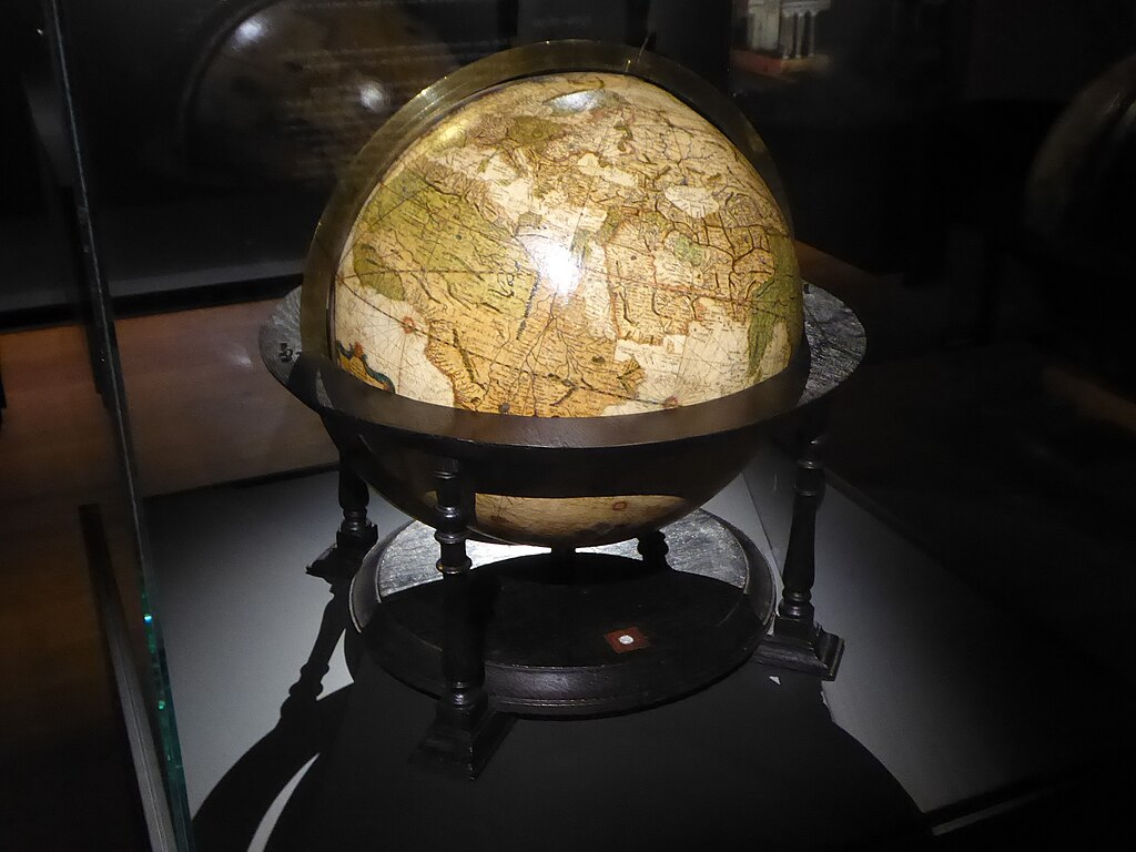
Coronelli World Globe (1690s)
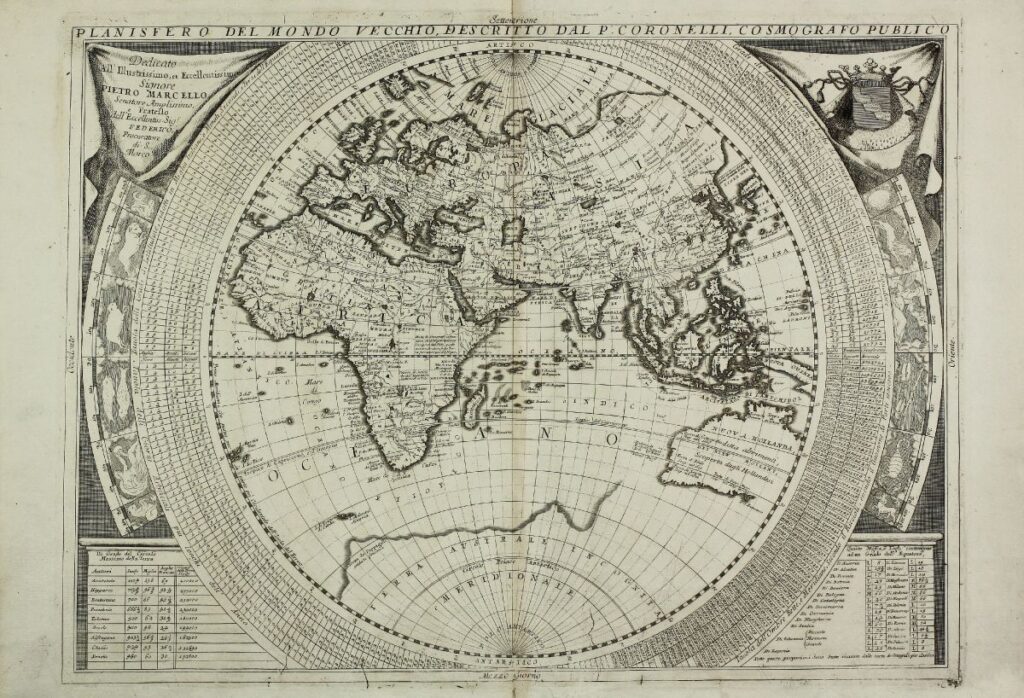
Vincenzo Coronelli’s 1690s world globe is a large and detailed globe that reflects the geographical knowledge of the late 17th century. It was a significant achievement in cartography, featuring highly detailed maps of the Americas, Asia, Europe, and Africa. Coronelli’s globes were some of the most advanced of their time and were commissioned by royalty and institutions. The original globes are rare and considered priceless, often found in major museums or private collections.
Smaller-scale reproductions of Coronelli’s globe are available for collectors, with prices generally ranging from $1,000 to $3,000, depending on size and craftsmanship. These reproductions capture the intricate details of Coronelli’s work and provide insight into the world of 17th-century exploration. The globe’s craftsmanship and historical significance make it a sought-after piece for cartography enthusiasts. Owning a reproduction allows collectors to appreciate one of the finest examples of early modern globe-making.
Blaeu Atlas (1660s)
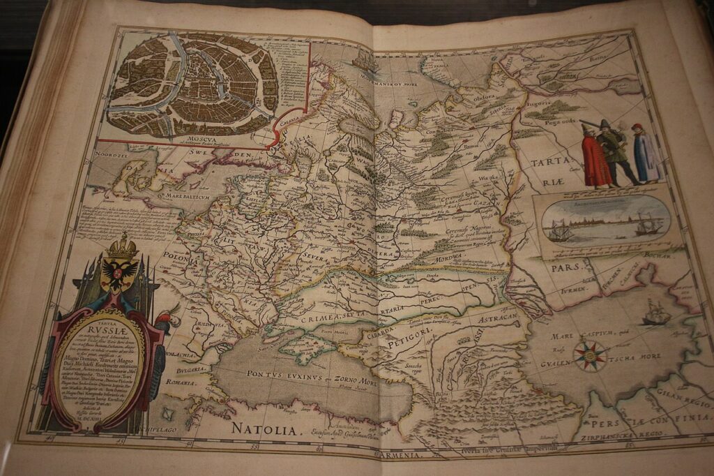
The Blaeu Atlas, created by Willem Blaeu in the 1660s, is one of the most important atlases of the early modern period. It includes comprehensive maps of Europe, Asia, Africa, and the Americas, with particular emphasis on the territories of the Dutch Empire. The atlas was known for its precision and high-quality craftsmanship, and it was widely used by explorers, merchants, and diplomats. Original atlases are highly sought after and can fetch prices of $10,000 or more at auction, depending on the condition.
Reproductions of the Blaeu Atlas are available for collectors, typically priced between $300 and $800 depending on the quality and binding. These atlases offer a detailed look at the world during the Dutch Golden Age and showcase the influence of Dutch exploration and trade. The maps within the atlas are known for their intricate detail and artistry, making it a valuable historical artifact. Owning a reproduction offers insight into the world’s geography during the 17th century.
Nuremberg Chronicle Map (1493)
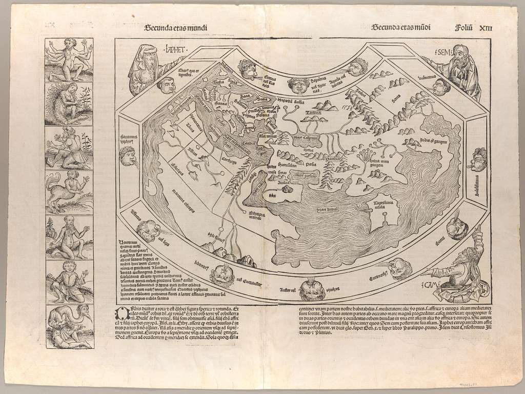
The Nuremberg Chronicle, published in 1493, includes one of the earliest printed world maps. The map was designed to show the known world according to medieval beliefs, with Jerusalem at its center. It combines geography with religious elements, reflecting how the medieval world viewed the Earth and its place in the universe. Original editions of the map are rare and extremely valuable, with prices reaching into the hundreds of thousands of dollars for well-preserved copies.
Reproductions of the Nuremberg Chronicle map can be found online for $20 to $100, making them more accessible for collectors and history enthusiasts. These maps offer a glimpse into medieval European thought and how religious belief shaped the understanding of geography. The Nuremberg Chronicle map is a significant artifact of the late 15th century and serves as a key example of how early maps integrated cultural and religious elements. Reproductions provide an opportunity to study this fascinating period in cartography.
Piri Reis Map (1513)
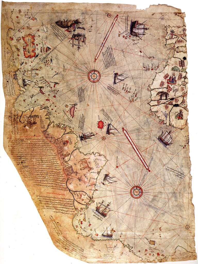
The Piri Reis map, created by the Ottoman admiral Piri Reis in 1513, is famous for its detailed depiction of the coast of South America. It is one of the earliest maps to show parts of the Americas with such precision, and it includes a portion of the coast of Antarctica, sparking much debate among historians. The map is based on several sources, including maps from ancient civilizations, and is one of the most important surviving artifacts of early cartography. Original versions are priceless and housed in the Topkapi Palace Museum in Istanbul.
Reproductions of the Piri Reis map are available, with prices typically ranging from $20 to $100, depending on the quality and size. The map’s inclusion of Antarctica and its early representation of the Americas make it a subject of intrigue for historians and cartographers. It stands as a testament to the Ottoman Empire’s extensive maritime knowledge and serves as a valuable resource for understanding early exploration. Reproductions allow enthusiasts to appreciate the map’s historical significance without the high cost of an original.
Mercator Globe (1541)
The 1541 Mercator Globe, created by Gerardus Mercator, is one of the earliest examples of a globe that used the Mercator projection. This globe was designed for navigation and marked a significant advancement in cartography. It was groundbreaking in providing a three-dimensional representation of the world. Original versions of the globe are exceedingly rare, with prices reaching several million dollars when they appear at auction.
Reproductions of Mercator’s globe can be found for $1,000 to $3,000, depending on the size and craftsmanship. These globes are popular among collectors and educators for their historical value and navigational utility. Mercator’s influence on modern cartography is profound, and owning a reproduction allows individuals to experience a key development in the history of mapmaking.
World Map by Abraham Ortelius 1595
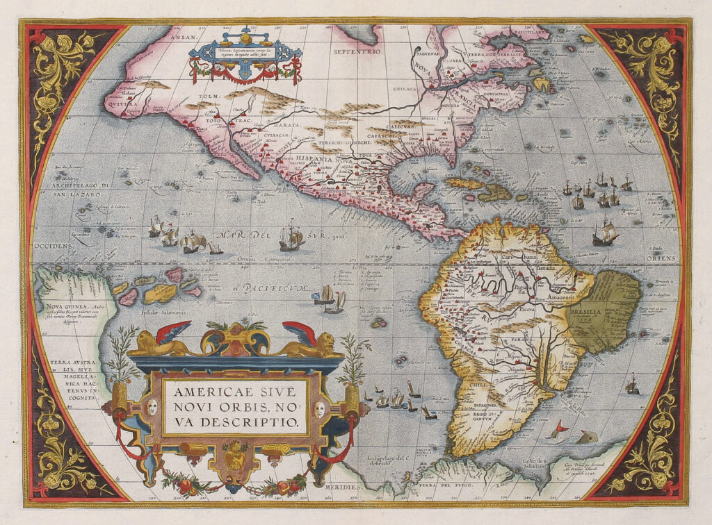
The 1595 World Map by Abraham Ortelius is one of the first modern atlases and plays a significant role in the history of cartography. This map was part of Ortelius’s larger work, “Theatrum Orbis Terrarum,” and provides a detailed representation of the world, including the newly discovered Americas. The map was revolutionary at the time for its accuracy and use of information gathered from explorers. Original versions of the map can fetch upwards of $50,000 to $100,000 at auction, depending on their condition and rarity.
Reproductions of Ortelius’s world map are available for a much lower price, typically ranging from $30 to $100. These reproductions are a great way to experience the cartographic advancements of the Renaissance period without the high cost of an original. Ortelius’s map helped solidify the modern concept of the world and influenced future mapmakers. Owning a reproduction is a great way to appreciate the legacy of this landmark map.
Exploring antique maps and globes allows us to connect with history in a tangible way. These pieces offer a window into the world of past explorers, their journeys, and the development of cartographic techniques. The stories they tell are rich in culture, science, and adventure. These artifacts remain relevant today, providing a glimpse into the foundations of modern geography and the people who shaped it.
This article originally appeared on Avocadu.